

Typhoon Nanmadol makes landfall in Japan
#GS-01 Geography
For Prelims:
About Typhoons:
- A typhoon is a mature tropical cyclone that develops between 180° and 100°E in the Northern Hemisphere aka the Northwestern Pacific Basin.
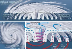
About Tropical Cyclones
- Tropical cyclones are violent storms with a diameter of about 320kms that originate over oceans in tropical areas and move over to the coastal areas.
- The direction of rotation of cyclones is influenced by Coriolis Force hence cyclones rotate in a counterclockwise direction in the Northern Hemisphere and in a clockwise direction while in the Southern Hemisphere.
- The passage of a tropical cyclone over the ocean results in the substantial cooling of upper layers of the ocean, which can influence subsequent cyclone development.
- Cyclones which form in each ocean around the world are named by the Regional Specialized Meteorological Centres (RSMCs) and Tropical Cyclone Warning Centres (TCWCs).
- Including the Indian Meteorological Department (IMD), there are six RSMCs present in the world and five TCWCs.
- The IMD is mandated to naming of cyclones as well as issuing advisories to 13 countries in the region namely Bangladesh, India, Maldives, Myanmar, Oman, Pakistan, Sri Lanka, Thailand, Iran, Qatar, Saudi Arabia, United Arab Emirates and Yemen.
The trigger mechanisms required for the formation of tropical cyclones are:
- A source of warm, moist air derived from tropical oceans with sea surface temperatures normally in the region of, or in excess, of 27 °C.
- Winds near the ocean surface blowing from different directions converging and causing air to rise and storm clouds to form.
- Winds which do not vary greatly with height – known as low wind shear. This allows the storm clouds to rise vertically to high levels.
- Sufficient distance from the equator to provide spin or twist.
Cyclones are called different names depending on the location, such as;
- Large sea surface with temperature higher than 27° C.
- Presence of the Coriolis force.
- Small variations in the vertical wind speed.
- pre-existing weak low-pressure area or low-level-cyclonic circulation.
- Upper divergence above the sea level system.